Using technology and digital data to inform the infrastructural design
Government Case Study: NSW Spatial Digital Twin – Transforming Urban Planning & Infrastructure

Wayne Patterson
Director, Spatial Operations,
NSW Department of Customer Service
Planning for a Digital Future
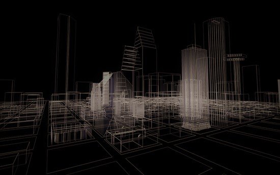
NSW, like all states, is planning for a digital future. Many people across the state are of course already using multiple devices and are very comfortable in the digital world, but to move even further forward, the state needs to go beyond current capabilities. As such, Wayne Patterson , the Director of Spatial Operations at the NSW Department of Customer Service, says that they are working on a spatial digital twin, which is essentially a “digital work bench for planning and infrastructure delivery.” It is not yet the futuristic digital tool that it is planned to be, but “a minimum viable product is available to everyone, not just to industry but to the general public as well with no login or password required for open access or open data.” There are secured areas for specific users, but for the most part, anyone can visit the URL and see it for themselves. It is open and available.
The NSW spatial digital twin is a new product, but the concept of a digital twin is not new. In fact, “there are literally thousands of digital twins or digital models of pretty much everything that exists in our built and natural environment.” The purpose of the one in NSW is “to utilise spatial information positioning technologies to position information and digital models in their real-world location.” In other words, it is designed to “integrate otherwise isolated individual models into their real-world locations.”
"
We are all moving down a digitally data driven society, and without having a spatial digital twin with all of its potential capabilities we can’t have smart precincts, we can’t have smart cities, we can’t have smart regions, and we can’t have a smart state, which is of course our ultimate goal.
It came about as a result of an NSW government report released in 2018 that “identified three key recommendations around digital information, access to information, and being able to integrate multiple sources of information pertaining to planning decisions and infrastructure investment.”
The current prototype is “the Foundation Spatial Data Framework which incorporates 200 – 300 key spatial data sets.” Based on the recommendations, it was initially “designed for the reduction of paper maps,” and thus is “almost entirely 2D.” However, a proof-of-concept has been developed “to see whether we could create 3D and 4D enabled representations for a complete set of foundation special data for the Smart Western City Deal.” The intention is for the current proof to be “maintained and progressively expanded” beyond the current parameters.
Most infrastructure projects these days are designed digitally, often with 3D renditions that allow users to see how the final product will look. But the spatial digital twin allows that model “to connect to its real-world location and we can see how it interacts with the water and sewer networks and the electrical networks. We’re also able to leverage IoT sensor networks, and we’re able to get a real-time picture of what is actually happening.”
Importantly, “it allows us to plan in the digital world before making mistakes in the real world.” For a state the size of NSW, “which is approximately 800,000 square kilometres,” this could make a big difference. Already there are “hundreds of users” of the 2D spatial data, and in fact, most people use some form of a digital twin “every time they use GPS or other your navigation systems.” The challenge of course is making it 3D and even 4D. The best global example of a spatial digital twin with those capabilities is in Singapore, but NSW is “740 times the size of Singapore,” so the challenge is infinitely greater, and eventually the intention is for it to cover all of NSW.
The 3D-enabled technology will allow users to see how new infrastructure interacts with existing infrastructure or nature, as an example. “Our first challenge was to actually create a digital 3D model of our built and natural environment, and we have been able to do that.” But it is the 4D technology that is really exciting. “4D is a time enabled the thematic representation of data going back in time, and maybe into the future too.” This means that users will be able to go back in time to see the imagery and the networks at a specific moment in time, and will be able to compare it to today. “What’s even more exciting about this is we can also go forward in time. All we need is access to information about what is being planned, what is being proposed, and how will it interact with what is there currently.”


The 4D technology, particularly as it relates to the future, might take some time to develop, but the 3D technology is already operational in specific areas of Western Sydney. “We are able to connect and bring in real-time feeds of what is actually happening there, and that subsequently enables the modeling component of it.” It has been really useful in the development of units. For instance, if a new block of units is placed in a particular area, “how will the existing infrastructure cope?” There are existing utilities and other things, and the spatial digital twin shows “individual property entitlements related to an authoritative address and plan.” This is would otherwise be a complex and lengthy regulatory process but has become “basic digital data that can be accessed in an easy-to-use way.” In many ways, this capability is “very cutting edge and something that offers a number of benefits across the complete lifecycle of assets.”
The NSW spatial digital twin has also been referred to as a “digital workbench” because it shows all of the digital imagery, networks, infrastructure, and planning assumptions relevant to the built and natural environment, in 2D, partially in 3D, and one day in 4D. “All of these are key ingredients that determine what can or cannot be done anywhere in our built environment.” Most of the data is open and accessible but “there are times when information should only be shared amongst controlled users until such time as that information becomes public,” and there are provisions for that.
"
“One of the key important considerations was that the NSW spatial digital twin be not just for government, but for the private sector and industry organisations too. We want to share information across both the public and private sector, and we want everyone to become much more empowered in their decision making, and more informed about where appropriate investment should be made. It is also simply for the average citizen to learn more about where they live, what is happening in their area, and how they can engage better.”Wayne Patterson, Director, Spatial Operations, NSW Department of Customer Service
Wayne Patterson, Director, Spatial Operations, NSW Department of Customer Service
The intention is for the spatial digital twin to be “ a key enabler of ePlanning and eConstruction. Digital data is essential for these processes, and automation will be necessary for eCompliance too.” Ultimately the intention is to have the spatial digital twin rolled out across all of NSW, and the early work on that “is very promising. The potential for significant time and cost savings for infrastructure planning and delivery are looking very positive indeed.”


![The Public Sector in the Age of AI: Leadership, Governance and Impact [Webinar]](https://cdn.publicsectornetwork.com/thumbnails/insight/feature_images/LI_Event_Banner_1_6e80b0.jpg.640x360_q85_autocrop_crop-center.jpg)