Across the public sector, smart technologies are being used to manage the delivery and maintenance of public assets.
Emerging digital tools are helping government to develop, operate, maintain, upgrade and dispose of assets, ensuring citizens have access to world class infrastructure.
Earlier this month, the federal government announced that is investing $110 billion into public assets through a 10 year infrastructure program, meaning that a range of infrastructure renewal projects are now underway. With an increased national deficit in the wake of COVID-19, it’s essential that this infrastructure investment is maximised, delivering sustainable and fit-for-purpose assets to our communities. Luckily, several digital technologies are helping to improve infrastructure planning, delivery, renewal and maintenance, helping government ensure their projects deliver a desirable Return On Investment (ROI).
Read on to hear about how governments across Australia are already leveraging smart technologies in asset and infrastructure management to deliver better infrastructure. Over the next year, integrating these technologies into asset management across state and federal government will make-or-break Australia’s record infrastructure investment.
1. A erial data capture technology
Gathering data about existing assets and la nd use is critical when making informed planning decisions.
Airborne data capture has become a popular method of collection with remote sensors and drones used to capture 3D photogrammetry, LiDAR imagery and other satellite photography. These data sets can then be leveraged by planners, engineers and maintenance teams to ensure public assets are being looked after.
Transport for NSW , NSW State Government, Australia
Transport for NSW began trialling the use of drones in 2019 for the management of incidents, assets, equipment and congestion. In 2020, the programme was extended to assist with emergency response during the Blue Mountain bushfires. This year, TfNSW are using drones to survey and 3D map flood affected areas in the state , working to reopen roads in the state’s north. By capturing images of affected slopes on the Oxley Highway, engineers are able to survey the area and model repairs without putting workers’ safety at risk.
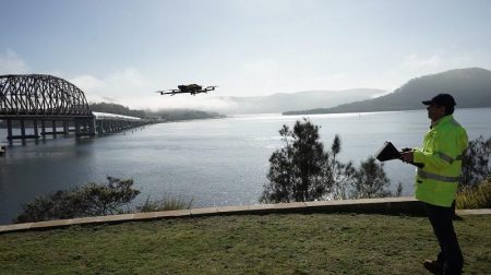
Source: Transport for NSW
Department of Resources, QLD State Government, Australia
Since 2005, the QLD Department of Resources have used data from airborne LiDAR sensors to manage the state’s natural resources. Light detection and ranging (LiDAR) is a remote sensing method used to survey the earth’s surface, and has been used by the Department to manage Mount Morgan – a copper, gold and silver mine that operated up to 1981, and is now abandoned.
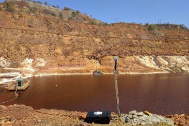
Source: International Mining
The Department worked with Australian technology startup GlassTerra to install IoT LiDAR sensors at Mount Morgan to demonstrate the safety benefits of real-time tailings embankments monitoring. By conducting LiDAR monitoring, the sensors were able to sense unplanned movements of earth and notify planners and workers on-site.
Department of Environment Land Water and Planning (DELWP), Victorian State Government, Australia
Managed by DELWP, Vicmap offers highly valuable Victorian spatial data and information, retrieving much of its spatial data from aerial remote sensors.

Victoria State Government
Vicmap is a portfolio of spatial data and products, including high-resolution spatial imagery and LiDAR data with coverage across the State. Vicmap equips a wide range of State Government organisations and partners with data sharing and storage systems that can monitor urban growth changes, model major infrastructure projects and undertake asset condition and management tasks. It also gives stakeholders a more comprehensive understanding of in-situ conditions (vegetation, natural and non-natural features, shading) and siting conditions (orientation, topography, boundaries, land parcels), helping to inform planning and asset maintenance.
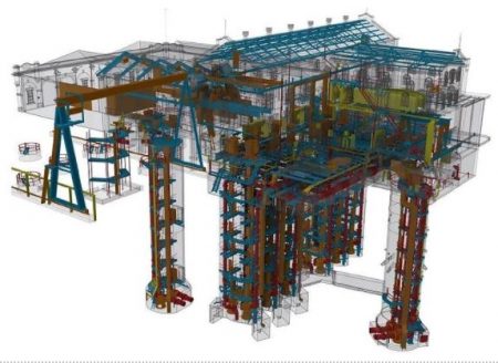
2. Digital Engineering (DE) (BIM, GIS, CAD and beyond)
Digital Engineering (DE) is a term used to describe the integration of several planning and project management technologies, including Building Information Modelling (BIM), Geographic Information Systems (GIS) and Computer Aided Design (CAD). DE itself is not a software – instead, it is a combination of digital processes that enable more productive methods of planning, designing, constructing, operating and maintaining assets through their lifecycle.
Department of State Development, Infrastructure, Local Government and Planning, QLD State Government, Australia
The QLD DILGP played a crucial role in developing the National Digital Engineering Policy Principals – a whole-of-government framework for implementing DE in infrastructure build and asset management ( published by the federal Department of Infrastructure, Transport, Regional Development and Communications) . The National Digital Engineering Policy Principles were developed to provide a framework for DE and BIM in design, delivery, operation and management of land transport infrastructure assets. In 2018, QLD DILGP released an additional state-wide framework on the principle for BIM Implementation – Digital Enablement for Queensland Infrastructure – and have continued to make strides in the DE space ever since.
Transport for NSW, NSW State Government, Australia
DE is revolutionising the construction industry in NSW, with emerging technologies enabling more collaborative and productive methods of project delivery and management throughout an asset’s lifecycle. Transport for NSW’s Digital Engineering Framework is accelerating infrastructure build and management by connecting emerging technologies with reliable and structured data. By supporting projects as they adopt new digital ways of working, TfNSW is utilising a range of data to shape smart cities for generations to come.
Source: Transport for NSW
Office of Projects Victoria, VIC State Government, Australia
In January 2020, the Office of Projects Victoria released the Victorian Digital Asset Strategy . Under the strategy, government-wide infrastructure projects use DE to enable information and data to be seamlessly transferred through all stages of a project and into the asset’s life. DE enables collaboration across government and industry, which means better project and community outcomes. Using digital technologies outlined in the strategy,
Source: Transport for NSW
government agencies are improving decision making, design processes, project delivery construction and asset management to optimise infrastructure in the community.
3. Digital Twins
A digital twin is a virtual simulation of a physical environment or process. It can model and forecast demand and predict maintenance, equipping agencies with real-time predictive analytics to inform their planning. Digital twins are driven by big data and capable of performing advanced analytics by machine learning, making these virtual models a powerful tool in infrastructure and asset management.
SEQ Water, Queensland State Government, Australia
The federal Department of Infrastructure, Transport, Regional Development and Communications have agreed to several City Deals – partnerships between three levels of government and the community to work towards a shared vision for productive and liveable cities. A key opportunity to arise from the City Deal for South East Queensland was the development of an SEQ Digital Twin as part of the TransformingSEQ: The SEQ City Deal Proposition.
Source: SEQ Water
SEQ Water have worked with industry to develop the Mt Crosby pumping station digital twin, using multiple capture technologies to overcome a number of physical limitations including tight underground spaces and poor air quality. The digital twin also seamlessly integrated with drone surveys and sub-surface radar to capture a comprehensive digital replica of the station; an important utility for Brisbane’s potable water that required significant refurbishment following the 2011 floods.
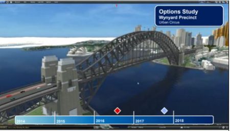
NSW Spatial Services, Department of Customer Service, NSW State Government, Australia
The NSW Spatial Digital Twin is part of the Western Sydney City Deal partnership that brought together federal, state, and local government to coordinate information that supports planning and broader liveability targets. The precinct level , analytics-aided, and standards-based 3D/4D digital twin pilot in Western Sydney focused on 3D analytics to urban micro-climate, including urban heat islands,
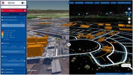
Source: NSW Spatial Services
temperature propagation, shadowing and its effect on pedestrian thermal comfort, mobility and walkability across selected urban scenarios . Digital Twins have the potential to improve data ingestion protocols, data management, workflows and real-time data analytics for situational awareness, and the NSW government are now planning to expand the area covered from 8,300km² to 801,150 km² in a state-wide project.
Land Use Victoria, Department of Environment Land Water and Planning (DELWP), Victorian State Government, Australia
Launched in the 2020, Digital Twin Victoria is a pilot funded under the Victorian Government’s $45 million investment to modernise Victoria’s digital cadastre . Digital Twin Victoria brings together digital twin technology, rich 3D and 4D spatial data, artificial intelligence and sensor data to visualise and model places virtually, before investments hit the ground. The program focuses on building six core capabilities across government related to data, platforms, skills, analytics, governance and community engagement, helping government, industry, education and the community collaborate in planning, designing and maintaining public assets.
4. Virtual Reality (VR)
Virtual Reality (VR) is a computer-generated simulation of a three-dimensional image or environment. When using VR, engineers and planners can interact with simulated infrastructure in a seemingly real or physical way, usually by using wearable electronic equipment (such as a helmet with a screen inside or gloves fitted with sensors). Several infrastructure projects across Australia are already using VR to establish a shared project vision, anticipate operational challenges and obtain buy-in from a range of stakeholders.
T h e L e v e l C r o s s i n g R e m o v a l P r o j e c t ( L X R P ) , V ic t o r i a n S t a t e G ov e r n m e n t , A u s t r a l i a
The LXRP was established by the Victorian state government to oversee one of the largest rail infrastructure projects in the state’s history. This includes the elimination of 75 level crossings across metropolitan Melbourne by 2025, as well as a range of other rail network upgrades (such as new train stations, track duplication and train stabling yards). The Aviation Road level crossing removal project team has partnered with technology company Snobal to pilot a virtual reality solution that supports design testing and review.
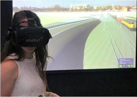
Source: LXRP
Instead of sifting through printed drawing sets and design mark-ups, engineers can put on the VR equipment and transport themselves to a virtual site, where they can interact with the proposed design as if they were there.
Wellington City Council, New Zealand
The City of Wellington has combined 3D geospatial capabilities with open government data to create a citywide Virtual Reality environment. Users can encounter the 3D city model in a Unity Gaming Engine, which has been a powerful and user-friendly engagement tool for the City. It has helped to faciliate collaborative planning and engagement with community, obtaining buy-in from stakeholders across industries, professions, ages and accessibility backgrounds.
Sydney Trains, Transport for NSW, NSW State Government, Australia
Transport for NSW has collaborated with Sydney Trains in using VR at the electrical learning centre in Sydney’s Greater West. By using VR in their training , electrical apprentices are being transformed into accredited rail electricians. Students of Sydney Trains can learn on rail-power equipment and, for the first time, use virtual reality in their training. Transport for NSW has also used VR as a customer engagement tool , leveraging immersive learning to improve Rail Safety by teaching the community to be more situationally aware with VR.
5. Cloud-based project management software
Project management software is a collaborative application that allows all parties to see who’s working on a project and when, including whether construction is on track. All stakeholders can see which tasks are assigned to them, when to start working, the work that needs to be done and who is free to do it. Everyone involved gives progress updates on their tasks as needed and marks off tasks when completed.
ACT City Renewal Authority, ACT State Government, Australia
Source: ACT City Renewal Authority
ACT City Renewal Authority’s Place Intelligence Dashboard is a real-time place analytics and automated reporting platform aligned with 17 place-performance indicators within the City Renewal Precinct of Dickson, Northbourne Avenue, Haig Park, Civic and West Basin. The Place Intelligence Dashboard provides data-based insights to drive urban renewal, using real-time analytics and automated performance reporting to provide information to planners and the community. The dashboard also allows for precinct-wide and sub-precinct wide reporting, allowing stakeholders to track changes over time to measure project progression. The dashboard allows for the ACT government to understand the current status of the city, measure the success of its initiatives, plan for future programs and projects, while tracking changes over time.
Sydney Water
Sydney Water is using cloud-based project management software to keep track of the delivery of $4 billion of infrastructure across three regional delivery consortiums (RDCs). The RDCs are responsible for end-to-end design, construction, maintenance and facilities management services for water and wastewater infrastructure across Sydney, the Blue Mountains and the Illawarra. The water utility has signed a five-year deal with software provider InEight to provide a platform for all parties involved in the capital works to collaborate.
At Public Sector Network ’s Asset and Infrastructure Management virtual event on Tuesday 15th June, Sydney Water’s Mark Simister (Head of Program Delivery) and InEight’s Rob Bryant (Executive Vice President, Asia-Pacific) will showcase Sydney Water’s digital transformation, including a case study on how they are leveraging cloud-based project management software in project delivery.
To hear from Sydney Water and other leading infrastructure agencies (such as the Office of Projects Victoria, QLD Department of Transport and Main Roads, Transport for NSW, Rail Projects Victoria. Wollondilly Shire Council and the University of Cantebury), register for Public Sector Network ’s upcoming Asset and Infrastructure Management virtual event today.